ROUTES ON RIVER Gauja
CĒSIS – LĪGATNE
(17 km along the river). 2 km behind the start point in Cīrulīši water tourist settlement Kvēpene. Behind it is the Kvēpene castle mound with the oak of the “pieclatnieks” Deer rock after 4.5 km. River islands. Settlement place Teņi. Amatas estuary. Leimaņu rock. Breathtaking Ķūķu rocks with 3-step rapids. Before Līgatne ferry Sprinģi rock. The only Gauja ferry of its kind in Līgatne, which is still operating. End or rout.
JĀŅRĀMIS – CĒSIS
9 km, the shortest canoe route 2-3 hours. Behind the water tourist camp “Jāņrāmis” a small rapids and a bridge. After 4 km the most beautiful Gauja cliffs – Ērgļu cliffs on the left bank with a footpath. The entry of the Vaidava river on the right bank and there used to be the Pielēkši ferry. The water tourist camp “Lenči – Lenčupe”, the Cēsis bridge. Behind the bridge 500 m
Cīrulīši beach with tent camping, volleyball courts, showers and sauna. Trip to Cēsis is possible, bicycle rental, etc. Cīrulīši cliffs, nature trails, spring lake all that at campsite “Žagarkalns”.Boat rental, equipment, boat and people transportation back and forth.
JĀŅRĀMIS – LĪGATNE
Day 1. Behind the water tourist camp “Jāņrāmis” a small rapids, a bridge. After 4 km the most dazzling Gauja cliffs – Ērgļu cliffs on the left bank with a footpath. Vaidava tributary on the right bank. Overpass ferry, water tourist camp “Lenči – Lenčupe”, Cēsis bridge. 500 m behind the bridge Cīrulīši beach with tent camping, volleyball courts, showers and sauna. Overnight stay. Trip to Cēsis is possible, bicycle rental, etc. Cīrulīši cliffs, nature trails, spring lake, “Žagarkalns”. Day 2 CĪRULĪŠI-LĪGATNE After 2 km water tourist camp Kvēpene. Behind it is the Kvēpene castle mound with the “pieclatnieka” oak. Briedīšu rock after 4.5 km. River islands. Settlement place Teņi. Amatas estuary. Leimaņu rock. Very stunning Ķūķu rocks with 3-step rapids. Before Līgatne ferry – Sprinģi rock. The only operating Gauja ferry is in Līgatne.
CĒSIS – SIGULDA
Starting place in our campsite – boat base in Cīrulīši. LĪGATNE After 2 km water tourist camp Kvēpene. Behind it is the Kvēpene castle mound with the
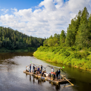
“pieclatnieka” oak. Briedīšu rock after 4.5 km. River islands. Settlement place Teņi. Amatas estuary. Leimaņu rock. Very stunning Ķūķu rocks with 3-step rapids. Before Līgatne ferry – Sprinģi rock. The only operating Gauja ferry is in Līgatne. Accommodation before the ferry in ‘Skaļupe’. LĪGATNE – SIGULDA 20 km. Raft trip – 1 day. The section is relatively calm, approaching Sigulda
the current becomes very moderate. On the way on the left bank Jumprava rock, water tourist camp “Katrīna”, on the right Katrīna rock. On the left bank Līgatne Nature Park – 1.5 hours field trip. After 2km Gūdu cliffs (on the right bank). Further, water tourist camp “Paslavas”, Launagu rock. In the route there are 3 more water tourist camps – “Brasla”, “Bērzi” and “Vējupīte”. Accommodation is recommended in ‘Bērzi’. Approaching Sigulda, Turaida Castle can be seen on the right bank.
VALMIERA – CĒSIS
36.5 km, 2 days by canoe, without rushing and stopping. In this rout the rowing slalom base swings on the left bank. Complicated rapids. On both banks there is a city. A total of 4 bridges in the city. The river behind the rowing base is straight, calm, 2 km behind the last bridge, the Gauja National Park begins. Water tourist camp “Vītoli” and “Sapa”. 3 km behind the Sapa valley the river will become deeper, the ancient valley of the Gauja begins. On the left bank Liepa rock, after 2 km on the right bank Sietiņiezis – one of the most mesmerizing rocks of the Gauja. 1 km from
Sietiņiezis water tourist settlement Grīviņi, on the left bank Grīviņi cliffs. After 2 km on the left bank Līču-Laņģu cliffs (100 m from the shore). Water tourist camp “Rauna” on the left bank, also the estuary of the river Rauna. After 4 km kazu rock on the right bank. River with large bends, sandstone outcrops on the banks. A very picturesque and graceful route with a calm, quiet river.
SIGULDA – MURJĀŅU TILTS
20 km. By canoe boat 4-5 hrs. On the way to the right bank Devil’s Cave, Big Stone and water tourist camp “Big Stone”. Lorupe estuary on the left bank. Current steady, islands, lots of sand dunes.
STREŅČI – VALMIERA
20 km, 1 day by canoe. Classic Gauja route. The river is wide, lots of swimming places. In this route there is 6 Strenči rapids. Strongest at the Krāčupe estuary. Further on the river is smooth. 3 km before city Valmiera significant sandbanks. Before Valmiera Steep shores on the right bank of the river. A small rapids behind the “Steep Shores”.
VIREŠI – AŅŅI
49 km, a canoe trip rowing smoothly for 1.5 days (with stopping and at enjoyfull pace – 2 full days). In the part from Vireši to Gaujiena (approx. 4-5 hours) the river is shallow and rocky, on the banks there are small cliffs, good fishing places by rapids. Near the river there is a shop in Gaujiena. After approximately 4 h on the right bank there is the Republic of Estonia. To
get off at the right bank and spend the night, you need a permit and bring a passport of a citizenship of the Republic of Latvia. Wild, beautiful meadows and forests on the shore. Sand dunes, good swimming places and accommodation. The river is breathtaking and nature around is full of birds and wild beasts. Good fishing places, in the deepest pits, catches. There are practically no houses on the shores. It must be taken into account that in the section from Gaujiena to Aņņi bridge it is very difficult to end the trip and drive to the river to take boats and people away. A very beautiful route, suitable for those who are looking for silence and a little wilder nature and who like spinning.
LĪGATNE – SIGULDA
38 km. The canoe trip lasts 8-10 hours. The first section of the river is relatively calm, approaching Sigulda, the current becomes very calming. On the way on the left bank Jumprava rock and water tourist camp “Katrīna”, on the right Katrīna rock. On the left bank, Līgatne Nature Park – 1.5 hour excursion. After 2km Gūdu cliffs (on the right bank). Further, water tourist camp “Paslavas”, Launagu rock. In this stage there are 3 more water tourist camps – “Brasla”, “Bērzi” and “Vējupīte”. Approaching Sigulda, Turaida Castle can be seen on the right bank.
AŅŅI – SPICRĀMIS
20 km, 5 hours by canoe or 1 day at easy pace. The river flows slowly, surrounded by forests, a long island in the middle of the river. Lots of water birds, favorable fishing spots. Lots of berries and mushrooms in the forests.
SPICRĀMIS – STREŅČI
18 km, 6 hours by canoe because the current is very harmonious. On the shores there are pine forests, at the estuary of the Vija there is a rock on the left side. Quiet section with typical banks of the Gauja without any special surprises.
ROUTES ON RIVER SALACA:
MAZSALACA – STAICELE
40 km. Canoeing can be less than 2 days in slow rowing, without haste and with stops in the most scenic places. In our opinion, one of the most beautiful routs of river tourism in Latvia. The river is picturesque, especially Mazsalaca Nature Park with caves and cliffs. Lots of attractions in the park. The current is getting more brisk, there are a lot of steep shores, streams, but you can find quiet, clean swiming places. A good place for rest on the right bank of the river “EŽI”. Rapids before Vīķi. Behind Vīķi, the current is slower, the river with broad bends. In this stage there are some good fishing spots in the rapids. The dam of the former paper mill can be crossed at the Staicele itself, but all safety precautions must be observed, it is recommended to unload the goods from the boats and transfer them by hand.
STAICELE – SALACGRĪVA
45km. This route would also be suitable for a leisurely, two-day canoe trip. River banks are steep, sandstone outcrops, the current is getting faster, rapid flows are beginning. Good place for rest “MAČKALNI”. Further on, the river becomes even faster, with many small rapids and islets. Behind the “Mērnieki” a lot of rocks and rapids. The most beautiful are the Red Cliffs – 500m long. Behind the Vecsalaca River, lamprey, however, it may difficult to get through.
VECATE – MAZSALACA
12km. By canoe boat 3-4 hrs. The width of the river is narrow, the current is slow. This stage is very calm and quiet. Meadows, fields on the shores. A suitable rout for beginners to learn rowing skills. Good fish places. Shop in Mazsalaca near the river.